Introduction to the London Underground
The London Underground, fondly known as the Tube, is a rapid transit system serving the city and its suburbs. As the world’s oldest underground railway system, its history dates back to 1863. Today, the London Underground spans across 11 lines, serving 270 stations, making it a pivotal part of the city’s infrastructure and an indispensable tool for navigating the sprawling metropolis.
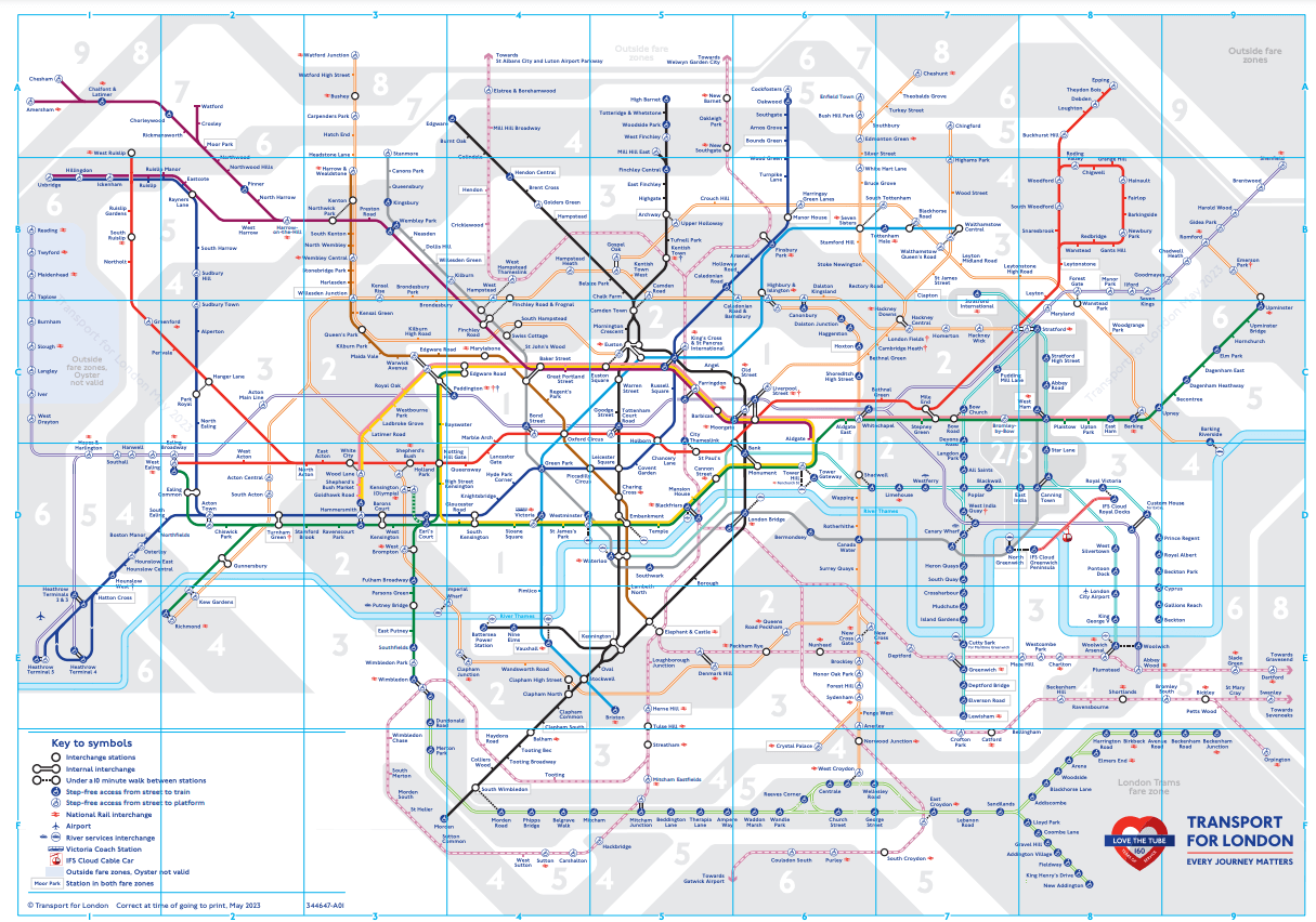
For anyone new to London, the tube map (officially called the London Underground Map) is an essential piece of navigational material. The tube map, provided by Transport for London (TfL), is a marvel of design, transforming the complex network of the London Underground into an easy-to-understand guide. To get a sense of this design brilliance, download the latest Tube Map from TfL’s official website.
The History of the London Underground
The London Underground’s inception dates back to the Victorian era when the city was grappling with heavy congestion due to the rapid growth of horse-drawn vehicles. The first line, the Metropolitan Railway, was opened in 1863 and ran from Paddington to Farringdon. It played a crucial role in the expansion of London by connecting the city’s central hub with its outer areas. Here’s a closer look at the history of the London Underground, provided by TfL.
The tube map Londoners and tourists are familiar with today owes its design to Harry Beck, a draughtsman at the London Underground Signals Office. His revolutionary design, launched in 1933, abstracted the complex layout of the Underground lines, stations, and zones into a simple, easy-to-read diagram. This article provides a deeper dive into the history of the Tube map.
How to Use the Tube Map
Using the tube map can seem overwhelming at first, given the myriad of lines crisscrossing the city. However, it’s surprisingly easy to navigate. The map uses unique colours to represent each Underground line. Stations are marked with a tick, and any station where you can switch lines is represented by a white circle.
The Tube Map is not geographically accurate. It is a schematic representation, designed to simplify complex routes and interconnections. Here’s a closer look at the design philosophy behind the Tube Map.
Understanding Fare Zones
The London Underground is divided into fare zones 1 to 9. Zone 1 is Central London, while Zones 2-9 represent areas farther out. Fares depend on how many zones you travel through. The Tube Map provided by TfL includes these zones, making it easier to calculate your fare. This guide provides a detailed explanation of the TfL fare zones.
The Tube Lines Explained
Understanding the London Underground is a task made significantly simpler by understanding its lines. Here, we delve into the various tube lines, their paths, and the main stations they service.
The Bakerloo Line
The Bakerloo Line, coloured brown on the tube map, runs between Harrow & Wealdstone in suburban north-west London and Elephant & Castle in south-east London. It serves key locations like Paddington, Baker Street, and Waterloo. Here is a detailed route map for the Bakerloo Line.
The Central Line
The Central Line, represented in red on the tube map, is one of the busiest lines of the Underground. It stretches from West Ruislip in the west to Epping in the north-east, passing through critical hubs like Oxford Circus, Bank, and Stratford. For more details, check out the Central Line’s route map.
The Circle Line
The Circle Line, depicted in yellow on the tube map, forms a loop around Central London, making it the perfect choice for tourists. It stops at many tourist destinations, including the Tower of London, St. James’s Park, and Notting Hill Gate. Find out more about the Circle Line.
The District Line
The District Line, coloured green on the tube map, is one of the busiest lines, stretching from Upminster in the east to multiple western branches, including Wimbledon, Richmond, and Ealing Broadway. Learn more about the District Line.
(Continuing in the same fashion for the other lines)
Accessibility on the London Underground
TfL is committed to making the Underground accessible for all passengers. Currently, over 70 stations offer step-free access from the street to the platform. This critical information is included in the Tube Map to aid passengers with mobility issues. Check out the latest step-free Tube guide from TfL.
Underground Etiquettes
The Tube is used by millions of people every day, making it crucial for passengers to follow certain etiquettes. Stand on the right when using escalators, allow passengers to alight before boarding, and remember to offer your seat to those who may need it more than you.
Future Developments
The London Underground continues to evolve. With expansions, refurbishments, and new technologies, TfL aims to enhance the passenger experience continually. Stay up-to-date with TfL’s future plans for the Underground.
Conclusion
The London Underground is more than a metro system – it is a testament to London’s growth and resilience. It is also an iconic part of the city’s cultural identity. Whether you’re a first-time visitor or a seasoned Londoner, the Tube and its ingenious Tube Map are your keys to the city.
Remember, it’s not just about reaching your destination; it’s also about experiencing the journey. As the saying goes, “Mind the Gap.”
Other metro maps
Make sure to check out other metro maps in capitals around the world. For example the DC Metro Map in the capital of The United States of America, Washington DC. Or the ever expanding MRT Map of Singapore. Also the subway in the capital of Sweden known as one of the longest art exhibitions in the world with over a 100 stations, each with unique art on its platform. Find your way around the “exhibition” with the Metro map Stockholm.